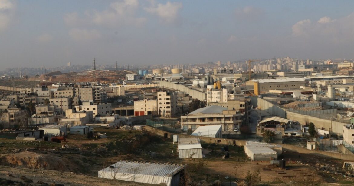
Bir Nabala is one of the towns of the Jerusalem Governorate. It is surrounded by the Israeli separation wall on most of its sides, isolating it from the surrounding towns and cities, and most of its people live from agricultural activities.
the site
Bir Nabala is located northwest of Jerusalem, 8.7 kilometers away. It rises 726 meters above sea level.
It is bordered to the east by the town of Al-Ram, to the north by the town of Al-Jadira, to the west by the town of Al-Jib, and to the south by Beit Hanina.
Label
Bir Nabala was named after a water well in the old town, which was the only source of water for the town’s residents. Then this well became one of the most important archaeological sites in the village.
The word “Nbalat” in ancient Arabic dialects means a basin or vessel, and another story says that the name is a modification of the name of “Nbalat”, a village that was in the vicinity of the town and whose features have disappeared.
Population
According to the general census of population and housing conducted by the Palestinian Central Bureau of Statistics in 2007, the population of the town of Bir Nabala reached about 6 thousand people.
Other unofficial statistics show that the population of Bir Nabala in the second decade of the 21st century became about 15 thousand, before it decreased again due to the restrictions of the occupation and the expansion of settlement.
the date
Following the Nakba in 1948, and after the armistice agreements of 1949, Bir Nabala came under Jordanian rule, but after the Nakba in 1967 it fell into the hands of the Israeli occupation.
In 1994, the town witnessed the kidnapping of Israeli soldier Nahshon Wachsman, in a military operation carried out by the Izz al-Din al-Qassam Brigades – the military wing of the Islamic Resistance Movement (Hamas) – in response to the massacre at the Ibrahimi Mosque in Hebron.
The Qassam Brigades captured soldier Wachsman at a position for Israeli soldiers inside the 1948 territories, then they took him to a house that had been prepared in advance in the village of Bir Nabala. The operation ended after the occupation forces stormed the headquarters of the Qassam unit that captured the soldier in an attempt to free him.
But the attempt led to the killing of the captured soldier, in addition to the commander of the storming unit and a third soldier, and about 20 soldiers were injured.
From the 1970s until the construction of the Israeli separation wall in 2004, the village of Bir Nabala was characterized by attracting residents to it, as its geographical location is characterized by its location between the north and the south, and between the cities of Jerusalem and Ramallah. It is also distinguished by its location from east to west, close to the cities of Al-Ram, Hizma and Shuafat across the enclave. The villages west of Jerusalem reached Jaffa via a main road to the coast, and easy movement from there to the cities of the occupied interior, and its markets were sufficient to meet the needs of its residents and visitors.
In early 2006, the Israeli occupation forces closed Palestine Street, which runs through the village of Bir Nabala, two years after the start of construction of the separation wall that surrounded the village from most directions and separated it geographically from its surroundings extending to the occupied city of Jerusalem.
Economy
The village of Bir Nabala has fertile lands suitable for growing olives and vegetables, and due to the abundance of water, the people of the town are interested in agriculture.
In terms of economic and commercial establishments and institutions, there are cleaning materials factories in the community, and handicraft shops such as blacksmithing and carpentry, as well as shops that provide the daily needs of the population.
The occupation aims to destroy the economy in the town of Bir Nabala in order to strengthen the economy of the Atarot industrial settlement, which is separated from the town only by the wall. It has become a large industrial city, and the occupation is working hard to facilitate work in it and the access of merchants to it, even though in the past it competed with the markets of the town of Bir Nabala.
The most important landmarks of Bir Nabala
There are two mosques in the town of Bir Nabala: Hajj Tawfiq Al-Nabali Mosque and the old Bir Nabala Mosque. There are also some archaeological sites and areas, including: old houses and the water well after which the town was named.
In Bir Nabala there are archaeological remains from different eras, such as the Byzantine era, the remains of a tower from the Crusader era, and the buildings of the old town dating back to the Ottoman era.
Settlement in Bir Nabala
In 2007, the occupation not only besieged the village of Bir Nabala from the eastern side, which connects it to Jerusalem, but also completed the construction of the wall to surround it from all sides and keep it in contact with the world through only two entrances, one of which connects to the villages northwest of Jerusalem that are also besieged by the wall, and the other entrance is closed by the occupation. Sometimes with military checkpoints, these villages are linked to the city of Ramallah.
Immediately after the construction of the wall, the population of the town decreased from 15,000 citizens to less than 5,000.


